Hurricanes: Here we go again
Forecasters: Our cool early spring might signal busy hurricane season.
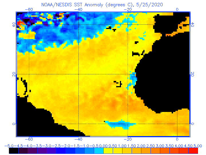
Sea surface temperatures in much of the tropical Atlantic are averaging 1 to 2 degrees Fahrenheit above normal, and forecasters warn that could spell trouble when the tropical-storm season gets under way,
Meteorologists at WSI Corp., a private service in Massachusetts, and Colorado State University have issued outlooks that look ominously similar.
WSI sees a total of 16 named storms - those with winds of 39 m.p.h. or better -- nine of those become hurricanes, with winds of at least 74 m.p.h., and five of them "major," or with peak winds of 111 m.p.h. or more
The Colorado State team of William M. Gray and Philip J. Klotzbach are going with 16 named storms, nine hurricanes, and four majors during the season, which begins June 1 and ends Nov. 30.
The long-term averages in the era of satellite observation in the three categories are 11, 6, and 2 in the Atlantic Basin, which inclues the Caribbean and the Gulf of Mexico.
Both outlooks, issued last week, cite the abnormally warm water temperatures in the Atlantic.
Those warmer waters are related to the coolish March and early April we experienced around here. The cool-ness resulted from a blocking pattern in the atmosphere over the North Atlantic.
Gray and Klotzbach point out that the patterns causes a weakening of the trade winds, which, in turn, allow the waters to warm.
One potential wild card would be an El Nino event, an anomalous warming of waters in the tropical Pacfic. That warming generates strong west-to-east winds in the upper atmosphere that can snuff out incipient hurricanes in the Atlantic Basin.
But the Colorado State team believes an El Nino is unikely, and WSI meteorologist Todd Crawford says that if the Atlantic stays warm, WSI's estimates might by under-done.